

Trending Now
 PM Modi inaugurates Noida International Airport, Boosting North India’s Multi-Modal connectivity
 Things You Can Do While on Long Train Rides: Stay Productive, Relaxed, and Entertained
 Rail Chamber launches 2026–27 National Membership Drive to strengthen Asia’s Railway Ecosystem
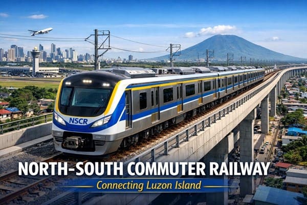 North-South Commuter Railway (NSCR): Modern Train Network Connecting Luzon Island
 India launched Bharat Taxi Service as First Cooperative-Owned Digital Mobility Platform
 India places World’s First Live Commercial Order for Hyperloop-Based Cargo Logistics
 How Weigh-in-Motion Systems Are Revolutionizing Freight Safety
 Women Powering India’s Electric Mobility Revolution
 Rail Chamber Launched to Strengthen India’s Global Railway Leadership
 Wage and Hour Enforcement Under the Massachusetts Wage Act and Connecticut Labor Standards
LiDAR survey begins for preparation of DPR for Mumbai-Nagpur Bullet Train Project
Anushka Khare
Posted on: 2021-03-15 08:30:00
Viewer: 4,996
Comments: 0
Country: India
City: Mumbai
New Delhi, India (Urban Transport News): The National High Speed Rail Corporation Ltd (NHSRCL) on 12th March 2021 announced that light detection and ranging( LiDAR) survey for the preparation of Detailed Project Report (DPR) for the proposed 736-km Mumbai-Nagpur High Speed Rail Corridor has been commenced by the team of SECON – Helica Joint Venture.
"The LiDAR survey for preparation of detailed project report (DPR) for Mumbai-Nagpur High Speed Rail Corridor (approx. 736 km) started today, where an aeroplane fitted with state of art Aerial LiDAR and Imagery sensors took the first flight and captured the data related to the ground survey," said the official statement issued by NHSRCL, adding the corporation is adopting Light Detection and Ranging Survey (LiDAR) technology which provides all the ground details and data in 3-4 months wherein this process normally takes 10-12 months.
Explaining the technology, the NHSRCL said that ground survey is a crucial activity for any linear infrastructure project as the survey provides accurate details of areas around the alignment. This technique uses a combination of Laser data, GPS data, flight parameters and actual photographs to give accurate survey data.
During the Aerial LiDAR survey, 150 meters of the area around the proposed alignment is being captured for the survey purpose. After the collection of data, Three Dimensional (3D) Topographical map of the corridor of the proposed alignment on a scale of 1:2500 will be available for designing of the vertical & horizontal alignment, structures, location of the stations and depots, Land requirement for the corridor, identification of project affected plots/structures, Right of Way etc.
To provide clear pictures of the structures, trees and other minute ground details, 100-megapixel cameras are being used for the LiDAR survey.
The proposed Mumbai-Nagpur High Speed Rail Corridor will connect Mumbai city with cities/towns like Nagpur, Khapri Deport, Wardha, Pulgoan, KaranjaLad, Malegaon Jahangir, Mehkar, Jalna, Aurangabad, Shirdi, Nashik, Igatpuri and Shahapur.
The Ministry of Railway has directed NHSRCL to prepare the Detailed Project Reports for seven High Speed Rail Corridors and the LiDAR survey technique will be used for ground survey in all the corridors.
For more details, please explore the Mumbai-Nagpur High Speed Rail page of Urban Transport News.


Anushka Khare
Anushka Khare is a Post Graduate in Journalism from Makhanlal Chaturvedi National University of Journalism and Communication, Bhopal (MP). She covers stories and updates from India.